
Superposition of Fort Lockhart view from Saragarhi
By guest blogger Richard A. Fowell (heliography expert)
The analysis showing locations visible to both forts places Saragarhi quite well in the East-West direction for a given position North or South, but is a bit fuzzy in the N/S direction. [1]
The period photos taken of Fort Lockhart from Saragarhi, however, can be used to accurately place Saragarhi in the N/S direction, but will be weak in the East-West direction.
By combining the two sources of information, we should be able to confirm the position of Saragarhi post without the need to lean on the statement that it was at the “highest” point on the ridge.
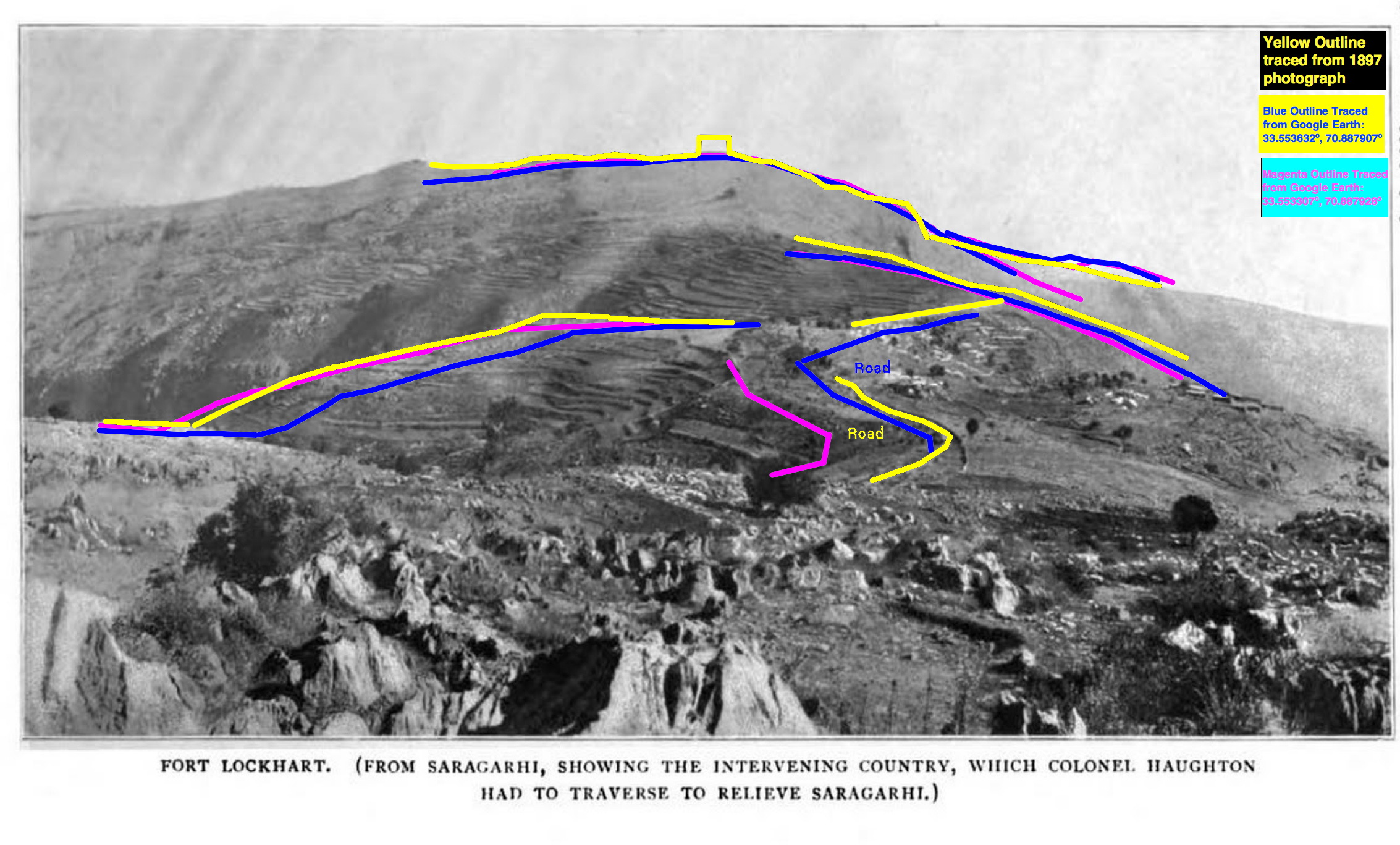
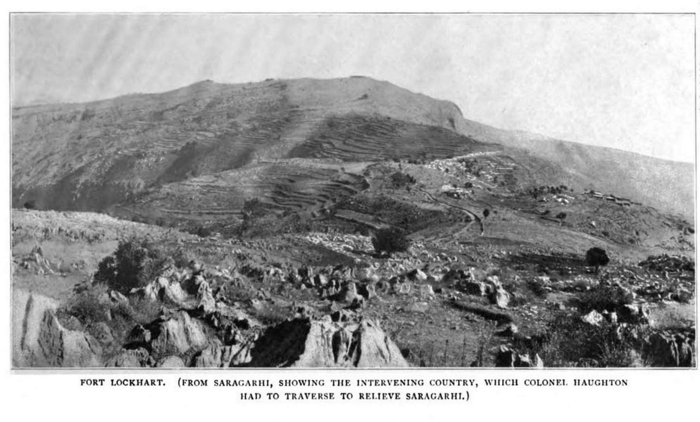
There are two photos in the book “Lieutenant-Colonel John Haughton, Commander of the 36th Sikhs” that show Fort Lockhart viewed from Saragahri. One was taken outside the Saragahri post, and the other was taken from inside.
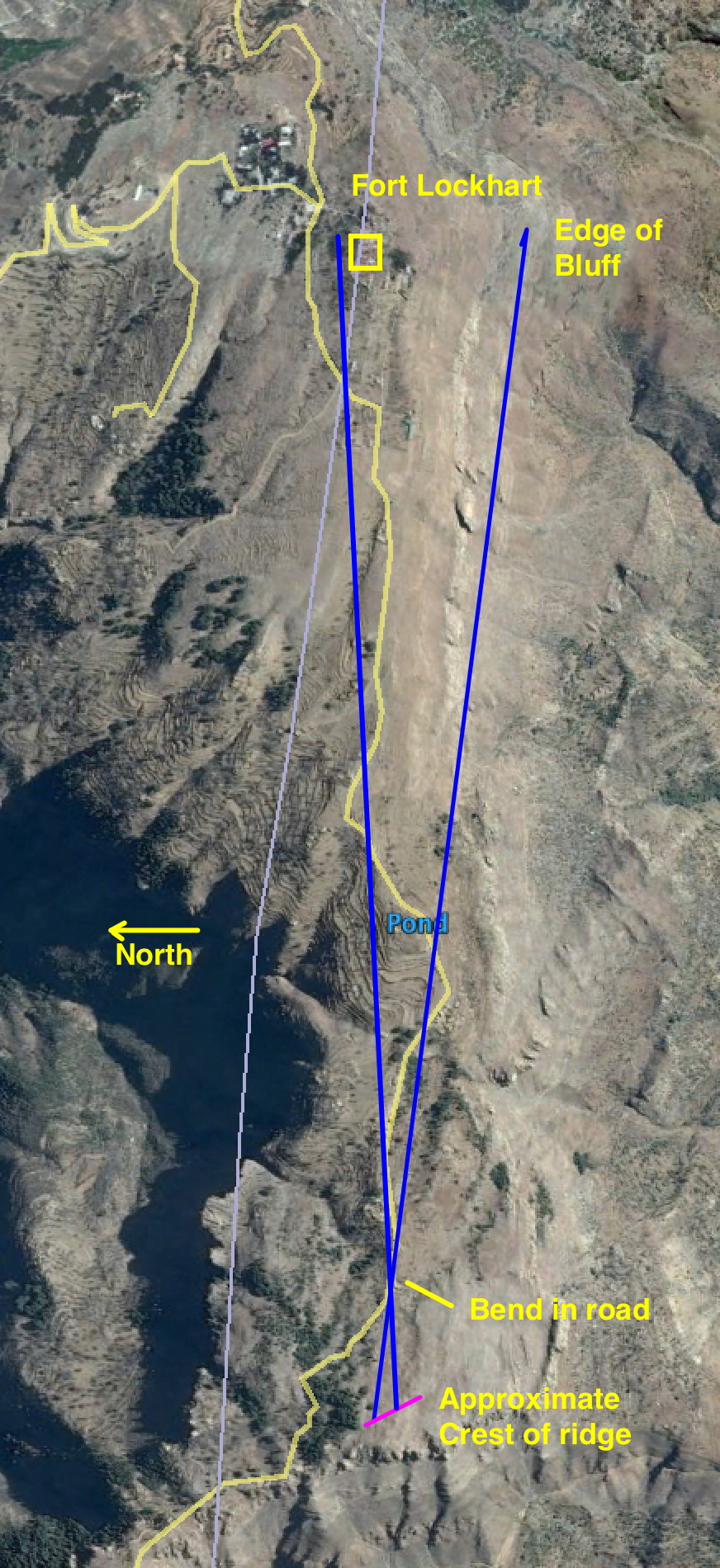
Determining the N/S location where the photo taken outside Saragarhi post is something we should be able to determine to exquisite precision by looking at the alignment between a nearby object still available in the modern day photos, but is much closer.
The bend in the Samana road close to Saragarhi is an excellent choice, since it skirts the north edge of the ridge, a feature which we can hope will not have shifted much in the last 120 years.
The photo shows how sensitive the apparent left-right position of that road curve with respect to horizon features (such as Fort Lockhart and the edge of the cliff south of Fort Lockhart) is to the North-South location of the photographer. (The colored feature lines were obtained by superimposing “ground view” images from Google Earth of the road and horizon from various locations.
The reason for this is perhaps clearer from the left image which shows how a line from the photographer through the bend of the road (blue lines) would shift as the photographer moves N/S along the ridge (magenta line).
My initial rough estimate is that the position the photograph was taken from is close to the left (North) end of the magenta line, as the cliff lip east of Fort Lockhart appears to the left of the nearby bend in the Samana road in the 1897 photograph, but I believe I can refine this further with a few more iterations.
The analysis showing locations visible to both forts places Saragarhi quite well in the East-West direction for a given position North or South, but is a bit fuzzy in the N/S direction.
The period photos taken of Fort Lockhart from Saragarhi, however, can be used to accurately place Saragarhi in the N/S direction, but will be weak in the East-West direction.
By combining the two sources of information, we should be able to confirm the position of Saragarhi post without the need to lean on the statement that it was at the “highest” point on the ridge.
There are two photos in the book “Lieutenant-Colonel John Haughton, Commander of the 36th Sikhs” that show Fort Lockhart viewed from Saragahri. One was taken outside the Saragahri post,and the other was taken from inside.
 I’ve been using the first one to narrow down the location of the post, but wanted to check how close the location it was taken from was to the post.
The answer seems to be – very close in the N/S direction.
With some more cogitation, I may be able to answer the question ” how close” …
Analysis:
I scaled the 2nd shot to match the first, rotated it -2.4274 degrees to line up the skyline (it seems that one or the other photo was not taken with the camera perfectly horizontal), cropped out the part that showed the “interesting” part of the horizon, and overlaid it with the first.
I then made an animated gif (third attachment) to flicker back and forth between the two for a “blink comparison”[1] of the two.
Besides the good horizon match, notice how well the two dark spots on the hill just below Fort Lockhart correspond in the two photos. If the two photos were taken from appreciably different N/S locations, then those spots would move left or right with respect to Fort Lockhart between the two photos.
Alas, since those two spots are not likely to be in modern photos, we can’t use this to check against modern photos, but it does provide confidence that if we can line up modern images with the photo taken outside Saragahri post, we will not be far wrong in locating in the N/S direction, where the post was.
(a) the high point of the ridge is quite flat in the N/S direction – a 66 meter change in position
for a eight ft change in height, per Google Earth’s estimate.
(b) The absolute height is fairly uncertain in current global DEMs (though I cling to the hope that
_relative_ height, which is all we need for the highest point, is relatively accurate for relative smooth, relatively flat terrain.
Of course, as stated in (a), relatively flat terrain makes locating the local high point, touchy.