Tag Archive: richard fowell

  1. Sunrise for the 21 at Saragarhi

    Leave a Comment

    The defenders of Saragarhi saw the sun rise over Fort Lockhart on the day of battle!
    By Richard Fowell, expert heliographer

    While doing some calculations to determine the heliograph settings to signal from Saragarhi to Fort Lockhart, I spotted something that would make a memorable scene in any film about the battle of Saragarhi. Viewed from Saragarhi, the sun rose over the walls of Fort Lockhart that day!
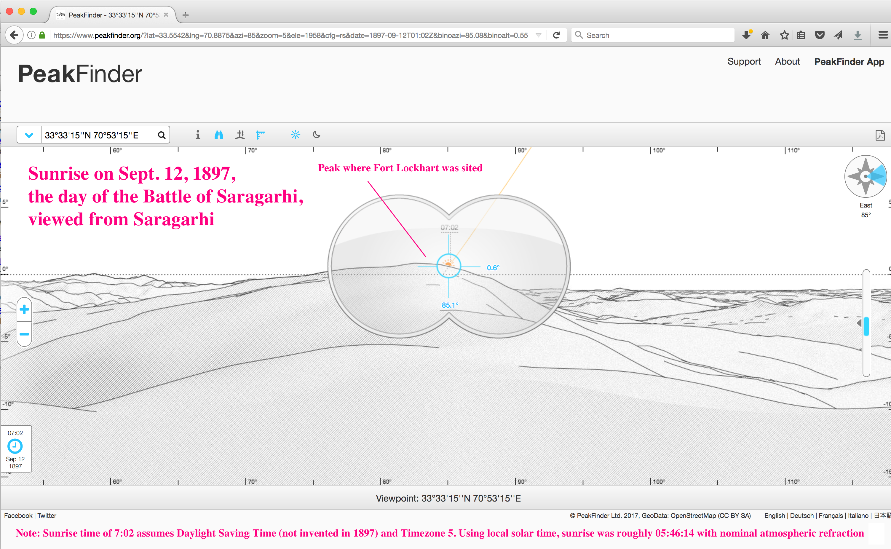
    I stumbled over this using the tools below, but as a quick sanity check, here’s a “quick look” at the sunrise on that day from Saragarhi using Peakfinder (screenshot also attached).

    PeakFinder’s  sunrise time of 7:02 apparently assumes Daylight Savings Time (not invented in 1897) and timezone 5 –  my computations below use solar time at Saragarhi. Note that the direction of sunrise does not depend on the choice of time reference.

    The profile that Peakfinder shows has the high point of the hill a bit left of sunrise, but the height profiles in the digital elevation models are a bit uncertain – satellite photos are a much more accurate guide to horizontal positions.

    The more detailed look is the second attachment, using the solar calculator at the US Government website of the National Oceanic and Atmospheric Administration (NOAA): https://www.esrl.noaa.gov/gmd/grad/solcalc/

    You can duplicate my results (screenshot attached) with the following inputs to: https://www.esrl.noaa.gov/gmd/grad/solcalc/

    Latitude 33.554167  Longitude 70.8875 [1] (Saragarhi)
    Time Zone: 4.726 [ Solar time: the latitude divided by 15 deg]
    Day Month Year: 12 Sept 1897 ( Battle of Saragarhi)
    Time: 05:46:14 [2]

    This is my calculated local solar time when the center of the sun would appear at the parapet of Fort Lockhart viewed from Saragarhi[2]. You will note  that at this point, the sun direction is through the cluster of modern-day buildings at the top of the hill where Fort Lockhart stood.

    There are, of course, various uncertainties in the exact location of Saragarhi and Fort Lockhart at the date of the battle, but based on the best information I have at the moment, the sunrise viewed from Saragarhi rose over the walls of Fort Lockhart that day.

    Regards,

    Richard A. Fowell

    [1] The position I used for Saragarhi is the high point of the ridge, as we have discussed,
    which jibes with the official report and the photo taken from Saragarhi of Ft. Lockhart.

    [2]  The time is chosen to get a sun elevation angle of 0.66 deg, which is what I calculate to be the apparent height of the Ft. Lockhart parapet
    The 0.66 deg elevation is based on 0.58 deg elevation of the ground at Ft Lockhart viewed from Saragarhi
    plus 0.08 deg for the 14 ft high walls Fort Lockhart is credited with (at range of 1.82 miles)
    I got the ground elevation angle viewed from Saragarhi from  http://www.heywhatsthat.com/?view=J2H95HEP
    (actually, rechecking this, the elevation of the base of the far walls is 0.57 deg, and range to there is 1.85 miles, but close enough, I won’t recalculate).

    [3] The legalese involved in using data from the NOAA site, crediting it, etc., is covered here:
    https://www.esrl.noaa.gov/gmd/about/disclaimer.html

  2. Is Saragarhi in the right place?

    Leave a Comment

    Through our Saragarhi Live videos we’ve connected with many people from around the world who are interested in the battle and our forthcoming film. A continuing conversation with one of these has been fascinating and forms the basis of this post – pinpointing exactly where Saragarhi is and why this location was the best for it.

    In researching for the book “Saragarhi: The Forgotten Battle” we found several primary sources which indicate and describe exactly where the signalling post was situated, including the original document for the placing of the Samana posts after the second Miranzai expedition.

    The official history from the India Army Intelligence Branch, 1908, puts it simply that: “Saraghari was … situated on the the highest point of the range between Fort Lockhart and Gulistan.”

    We took this research to pinpoint the site of the post on Google Maps, right next to the Samana Road.

    But why was this the best site? Could Saragarhi have been located somewhere else?

    Richard Fowell, a heliography expert from California, got in touch with some interesting insight, which we are publishing here with his kind permission.

    Using digital elevation maps (DEM), Richard found not only where Saragahri was located (33.554º N 70.888º E), but all locations where a relay post in between could have been sited.

    Below are his calculations:

    “Various accounts place Saragarhi at various distances from Fort Lockhart and Fort Gulistan, and variously north or south of the road (or line) between the forts. Since Saragarhi has been obliterated, we can’t directly locate it with Google Earth. However, we should be able to locate Saragarhi definitively from topography. Based on the below, I place it at 33.554º N 70.888º E.

    I began my analysis at Michael Kosowsky’s free site heywhatsthat.com. His site uses Google’s computerized contour maps (digital elevation models (DEMs) to find the highest point within a given radius of a location, to show areas visible from a given location and height, and to find the bearing and range to other points.

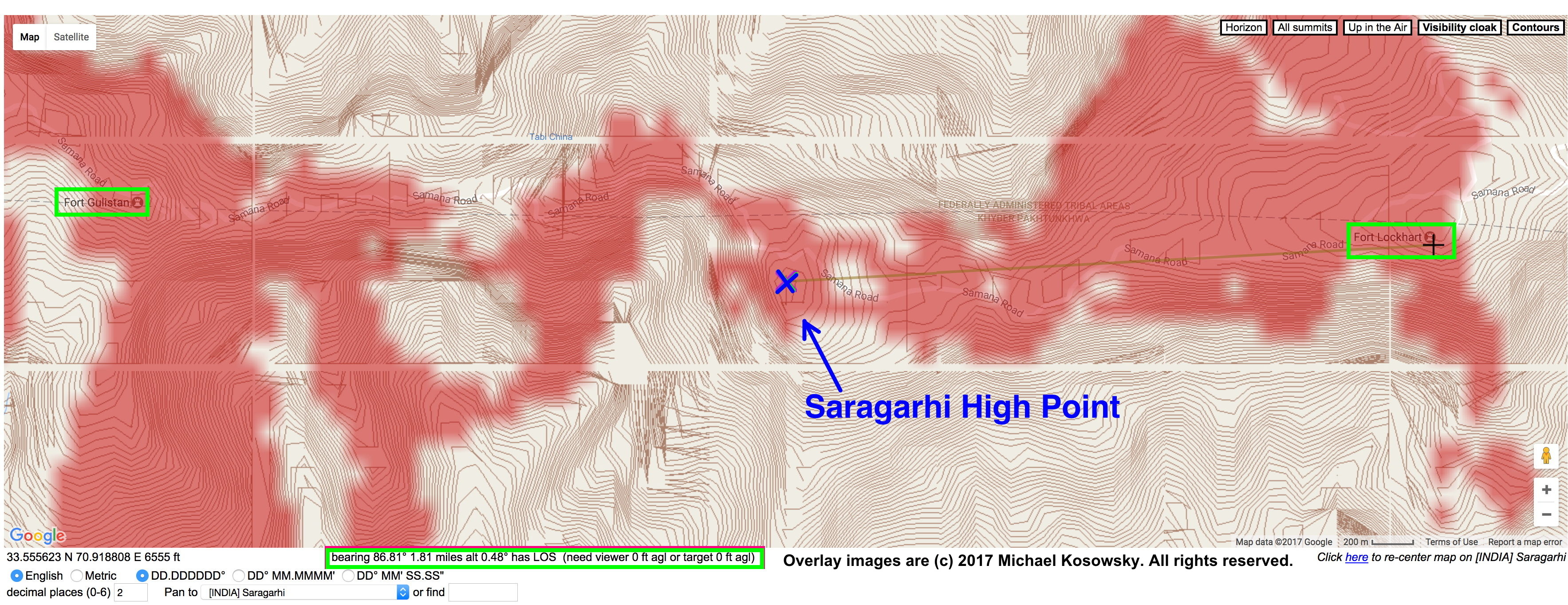
    Fort Lockhart and Fort Gulistan are marked on Google Maps – I began at a point midway between the two. The “Contours” option at heywhatsthat.com displays the ridge between the forts. As the 1908 official history places Saragarhi at the high point of that ridge,  I picked a point in the centre of the ridge and asked for the highest location within one mile.

    Heywhatsthat.com chose 33.554167º N 70.8875º E 6467 ft elevation. The areas visible from eye level at that point (6 feet above ground level (AGL) : 6473 ft) are tinted red in the first screenshot from the heywhatsthat.com analysis here: Saragarhi Post.

    This puts Saragarhi 1.8 +/- 0.1 miles (as the heliograph flash travels) from both forts It is south of, and 60 ft above, the crest of Samana Road.

    Some published accounts place Saragarhi post north of the road – how do we convince skeptics?

    DEMs aren’t perfect. The DEM for this region was probably based on Shuttle radar data, likely 90 m horizontal spacing and 16 m (53 ft) vertical accuracy (90% confidence), with any points in between interpolated (an “educated guess”) from that data.  The Google Earth DEM for this ridge puts  the location above 22 ft lower (6445 ft), and says the ridge high point is 66 meters SW, and eight feet higher, at 33.553673º N 70.887908º E 6453 ft.

    We know Saraghari was visible from both Fort Lockhart and Fort Gulistan – we can use this as a check.

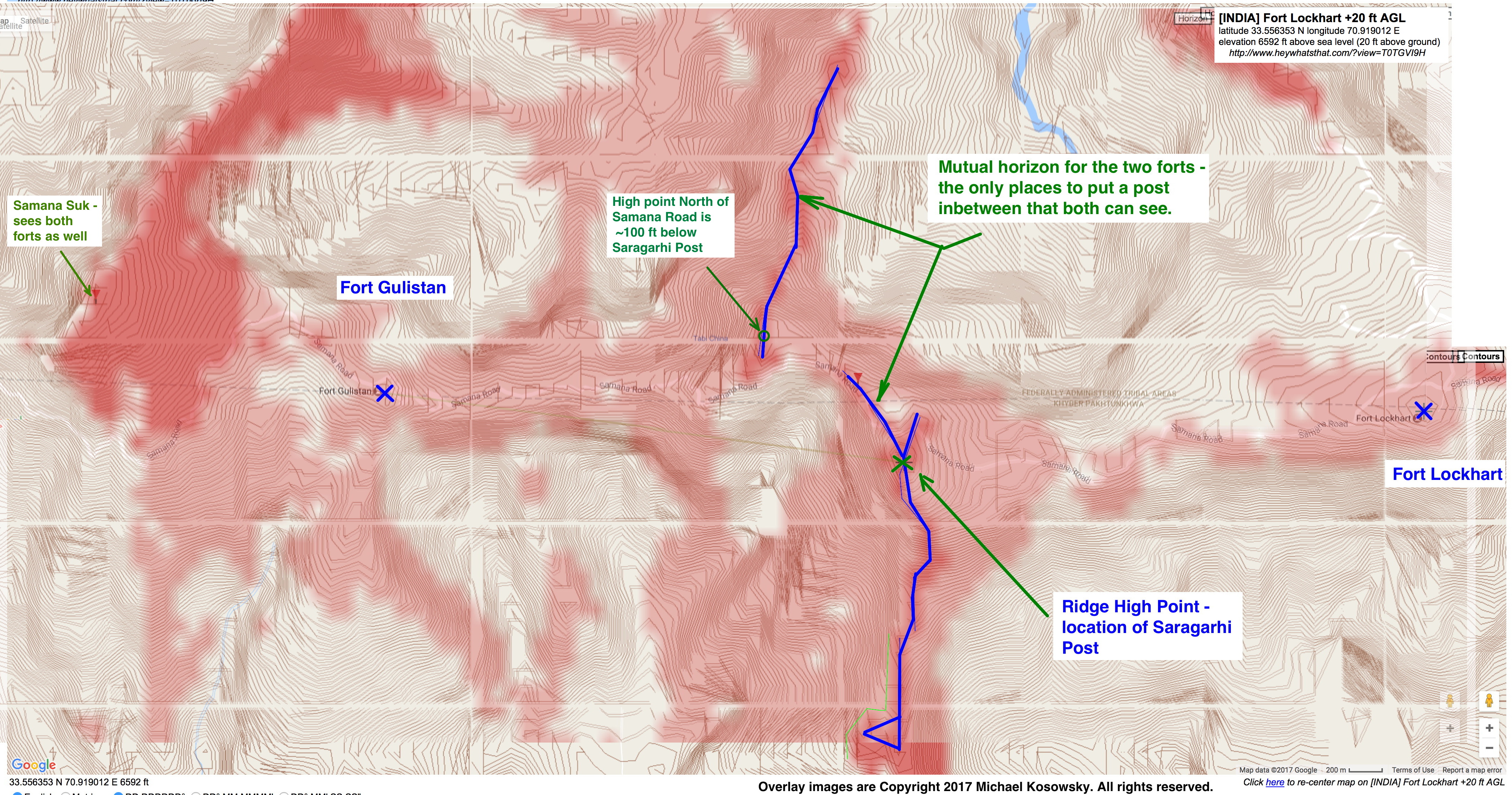
    The locations of Fort Lockhart and Gulistan are marked on Google Maps, with the buildings visible in “satellite” view.  I used heywhatsthat.com to pick the highest point in each fort. The 1908 official history says the forts had 14 ft walls, so I set the height to eye level above the walls (20 feet AGL).

    Heywhatsthat.com provided these views:

    Fort Lockhart +20 ft AGL: latitude 33.556353º N longitude 70.919012º E elevation 6592 ft above sea level

    Fort Gulistan +20 ft AGL: latitude 33.557208º N longitude 70.856536º E elevation 6086 ft above sea level

    I overlaid these views, with the top view set to 50% transparency, to get the second screenshot, where locations visible from both Lockhart and Gulistan are darker red.

    One interesting observation from the intervisibility map is that the heliograph station did not have to be placed between the two forts to communicate to both. [1]

    I sketched in blue lines to show all the locations between Lockhart and Gulistan that were visible from both. 
    I’ve marked an attractive alternate signaling site north of the road, about 1 km NW of Saragarhi post. Militarily, this northern location has the disadvantage that snipers at Saragarhi would (slightly) overlook it, but Fort Gulistan suffers the same disadvantage with respect to the slopes west of it.

    The northern point is 25 m lower than Saragarhi, so it is clearly not the highest point on a ridge, but it is a high point on the ridge. Are we putting too much weight on the adjective “highest” in the 1908 account?

    We can show that our location is correct by combining information from the DEMs with photogrammetry from photos of Saragarhi taken shortly after the battle. That will be the subject of my next communication.”

    Heywhatsthat.com overlay images are Copyright 2017 Michael Kosowsky. All rights reserved. Used with permission.

    [1] A contrarian choice would have been a signal post at Samana Suk, west of both forts. It would be within 5 miles of both forts – point-blank range for a heliograph. It would also offer advance warning for any incursion from the west.