Tag Archive: heliograph

  1. Sunrise for the 21 at Saragarhi

    Leave a Comment

    The defenders of Saragarhi saw the sun rise over Fort Lockhart on the day of battle!
    By Richard Fowell, expert heliographer

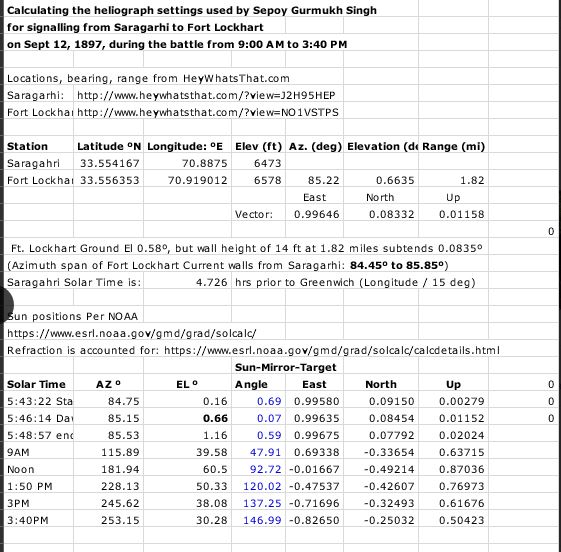
    While doing some calculations to determine the heliograph settings to signal from Saragarhi to Fort Lockhart, I spotted something that would make a memorable scene in any film about the battle of Saragarhi. Viewed from Saragarhi, the sun rose over the walls of Fort Lockhart that day!

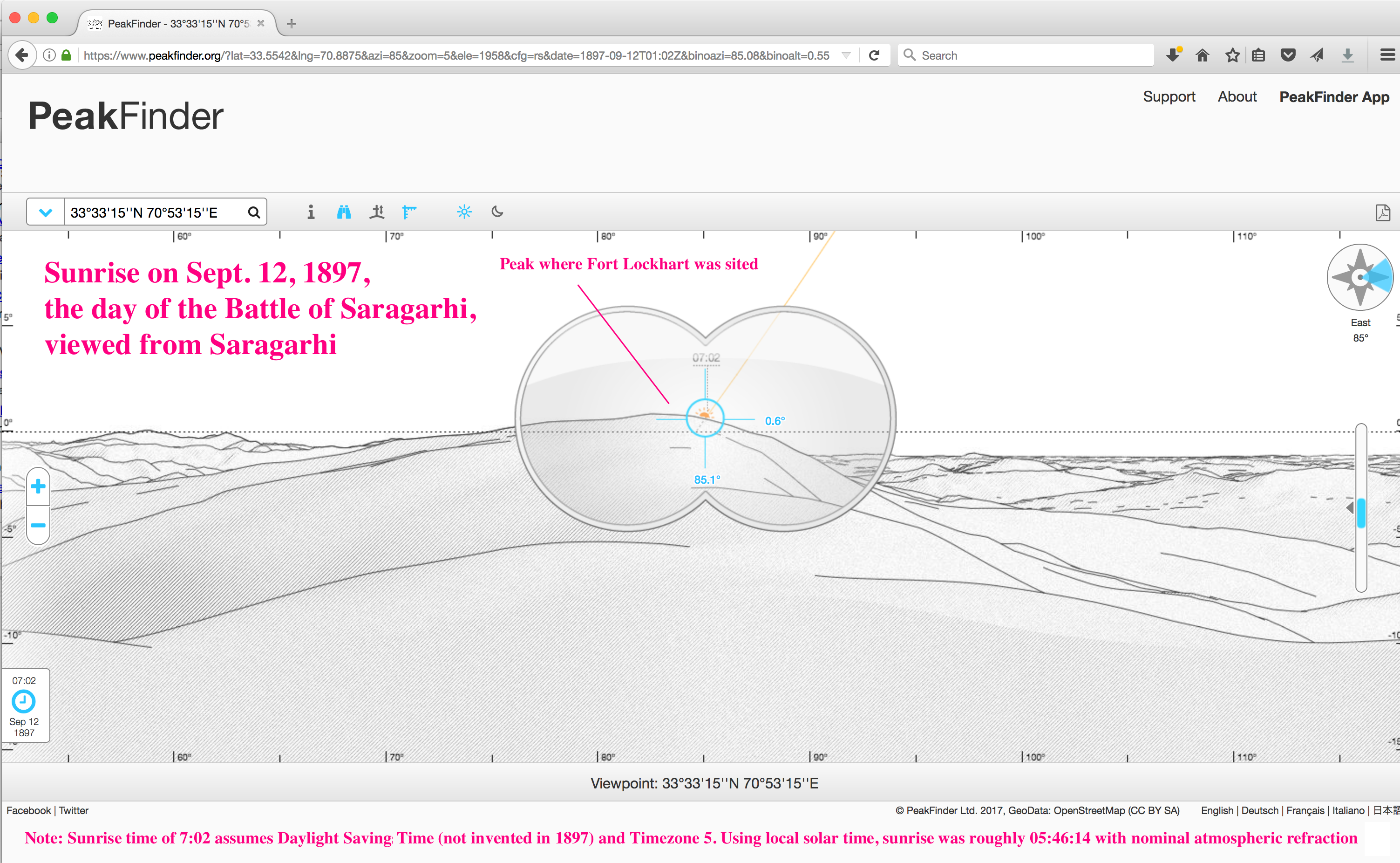
    I stumbled over this using the tools below, but as a quick sanity check, here’s a “quick look” at the sunrise on that day from Saragarhi using Peakfinder (screenshot also attached).

    PeakFinder’s  sunrise time of 7:02 apparently assumes Daylight Savings Time (not invented in 1897) and timezone 5 –  my computations below use solar time at Saragarhi. Note that the direction of sunrise does not depend on the choice of time reference.

    The profile that Peakfinder shows has the high point of the hill a bit left of sunrise, but the height profiles in the digital elevation models are a bit uncertain – satellite photos are a much more accurate guide to horizontal positions.

    The more detailed look is the second attachment, using the solar calculator at the US Government website of the National Oceanic and Atmospheric Administration (NOAA): https://www.esrl.noaa.gov/gmd/grad/solcalc/

    You can duplicate my results (screenshot attached) with the following inputs to: https://www.esrl.noaa.gov/gmd/grad/solcalc/

    Latitude 33.554167  Longitude 70.8875 [1] (Saragarhi)
    Time Zone: 4.726 [ Solar time: the latitude divided by 15 deg]
    Day Month Year: 12 Sept 1897 ( Battle of Saragarhi)
    Time: 05:46:14 [2]

    This is my calculated local solar time when the center of the sun would appear at the parapet of Fort Lockhart viewed from Saragarhi[2]. You will note  that at this point, the sun direction is through the cluster of modern-day buildings at the top of the hill where Fort Lockhart stood.

    There are, of course, various uncertainties in the exact location of Saragarhi and Fort Lockhart at the date of the battle, but based on the best information I have at the moment, the sunrise viewed from Saragarhi rose over the walls of Fort Lockhart that day.

    Regards,

    Richard A. Fowell

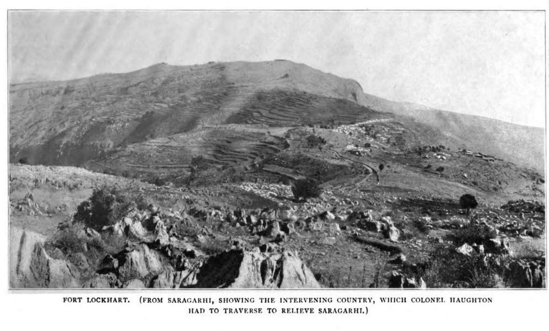
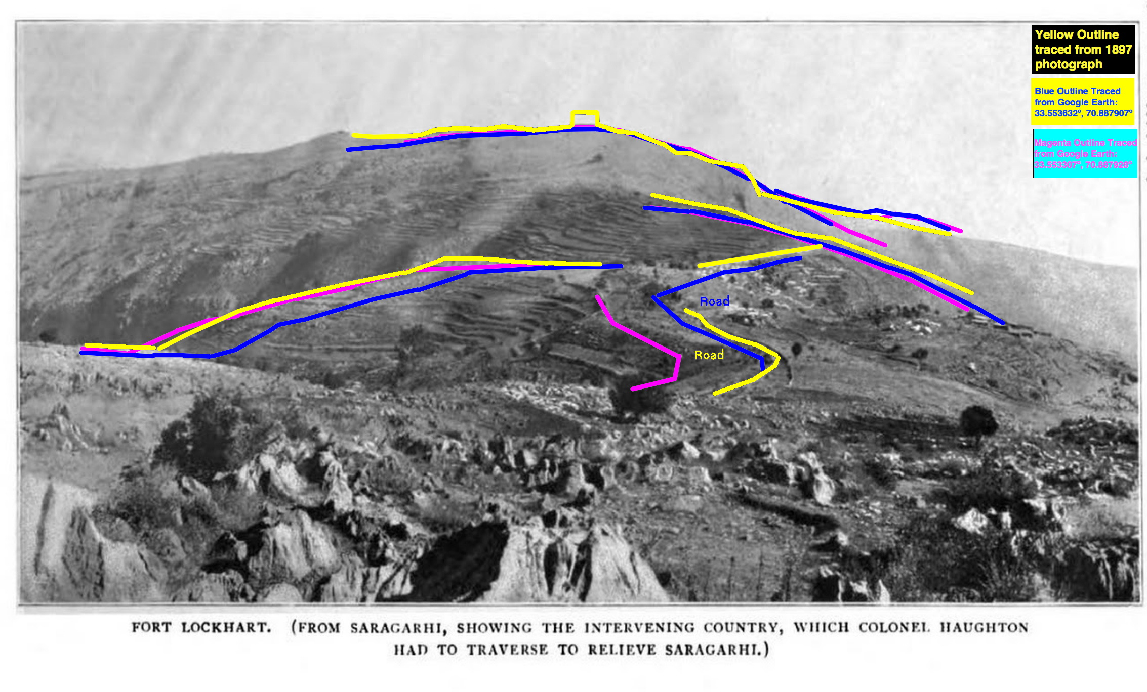
    [1] The position I used for Saragarhi is the high point of the ridge, as we have discussed,
    which jibes with the official report and the photo taken from Saragarhi of Ft. Lockhart.

    [2]  The time is chosen to get a sun elevation angle of 0.66 deg, which is what I calculate to be the apparent height of the Ft. Lockhart parapet
    The 0.66 deg elevation is based on 0.58 deg elevation of the ground at Ft Lockhart viewed from Saragarhi
    plus 0.08 deg for the 14 ft high walls Fort Lockhart is credited with (at range of 1.82 miles)
    I got the ground elevation angle viewed from Saragarhi from  http://www.heywhatsthat.com/?view=J2H95HEP
    (actually, rechecking this, the elevation of the base of the far walls is 0.57 deg, and range to there is 1.85 miles, but close enough, I won’t recalculate).

    [3] The legalese involved in using data from the NOAA site, crediting it, etc., is covered here:
    https://www.esrl.noaa.gov/gmd/about/disclaimer.html

  2. Superposition of Fort Lockhart view from Saragarhi

    Leave a Comment
    Superposition of Fort Lockhart view from Saragarhi
    By guest blogger Richard A. Fowell (heliography expert)


    The analysis showing locations visible to both forts places Saragarhi quite well in the East-West direction for a given position North or South, but is a bit fuzzy in the N/S direction. [1]

    The period photos taken of Fort Lockhart from Saragarhi, however, can be used to accurately place Saragarhi in the N/S direction, but will be weak in the East-West direction.

    By combining the two sources of information, we should be able to confirm the position of Saragarhi post without the need to lean on the statement that it was at the “highest” point on the ridge.

    There are two photos in the book “Lieutenant-Colonel John Haughton, Commander of the 36th Sikhs” that show Fort Lockhart viewed from Saragahri. One was taken outside the Saragahri post, and the other was taken from inside.

    Determining the N/S location where the photo taken outside Saragarhi post is something we should be able to determine to exquisite precision by looking at the alignment between a nearby object still available in the modern day photos, but is much closer.

    The bend in the Samana road close to Saragarhi is an excellent choice, since it skirts the north edge of the ridge, a feature which we can hope will not have shifted much in the last 120 years.

    The photo shows how sensitive the apparent left-right position of that road curve with respect to horizon features (such as Fort Lockhart and the edge of the cliff south of Fort Lockhart) is to the North-South location of the photographer. (The colored feature lines were obtained by superimposing “ground view” images from Google Earth of the road and horizon from various locations.

    The reason for this is perhaps clearer from the left image which shows how a line from the photographer through the bend of the road (blue lines) would shift as the photographer moves N/S along the ridge (magenta line).

    My initial rough estimate is that the position the photograph was taken from is close to the left (North) end of the magenta line, as the cliff lip east of Fort Lockhart appears to the left of the nearby bend in the Samana road in the 1897 photograph, but I believe I can refine this further with a few more iterations.

    The analysis showing locations visible to both forts places Saragarhi quite well in the East-West direction for a given position North or South, but is a bit fuzzy in the N/S direction.

    The period photos taken of Fort Lockhart from Saragarhi, however, can be used to accurately place Saragarhi in the N/S direction, but will be weak in the East-West direction.

    By combining the two sources of information, we should be able to confirm the position of Saragarhi post without the need to lean on the statement that it was at the “highest” point on the ridge.

    There are two photos in the book “Lieutenant-Colonel John Haughton, Commander of the 36th Sikhs” that show Fort Lockhart viewed from Saragahri. One was taken outside the Saragahri post,and the other was taken from inside.

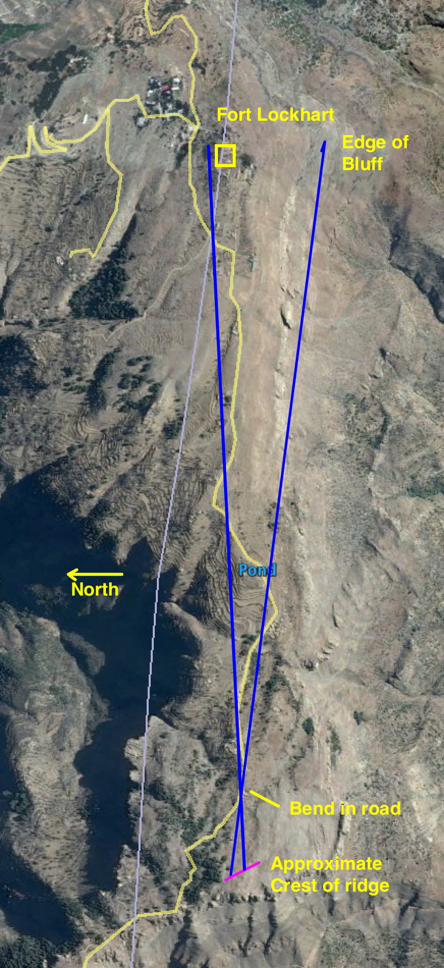
    I’ve been using the first one to narrow down the location of the post, but wanted to check how close the location it was taken from was to the post.

    The answer seems to be – very close in the N/S direction.

    With some more cogitation, I may be able to answer the question ” how close” …

    Analysis:

    I scaled the 2nd shot to match the first, rotated it -2.4274 degrees to line up the skyline (it seems that one or the other photo was not taken with the camera perfectly horizontal), cropped out the part that showed the “interesting” part of the horizon, and overlaid it with the first.

    I then made an animated gif (third attachment) to flicker back and forth between the two for a “blink comparison”[1] of the two.

    Besides the good horizon match, notice how well the two dark spots on the hill just below Fort Lockhart correspond in the two photos. If the two photos were taken from appreciably different N/S locations, then those spots would move left or right with respect to Fort Lockhart between the two photos.

    Alas, since those two spots are not likely to be in modern photos, we can’t use this to check against modern photos, but it does provide confidence that if we can line up modern images with the photo taken outside Saragahri post, we will not be far wrong in locating in the N/S direction, where the post was.


    [1] For two reasons:
    (a) the high point of the ridge is quite flat in the N/S direction – a 66 meter change in position
    for a eight ft change in height, per Google Earth’s estimate.
    (b) The absolute height is fairly uncertain in current global DEMs (though I cling to the hope that
    _relative_ height, which is all we need for the highest point, is relatively accurate for relative smooth, relatively flat terrain.
    Of course, as stated in (a), relatively flat terrain makes locating the local high point, touchy.


  3. How did Saragarhi signaller Gurmukh Singh configure his heliograph?

    Leave a Comment

    Guest blog by heliography expert Richard Fowell, California

    During the battle of Saragarhi, Sepoy Gurmukh Singh would have signaled Fort Lockhart with his heliograph configured with a single mirror early in the day, and with two mirrors later in the day.  The first attachment shows an 1886 illustration of the two configurations, and below that is a modern photo:


    The time of day at which Gurmukh Singh would have added the second mirror would have been 1:50 PM local solar time  which would have meant his noon signal would have been with the single mirror, and his 3pm  and final messages with two mirrors.

    Here is the reason why:

    When the sun and the target station are on the same side of the signaler, a single heliograph mirror will suffice. However, as the angle between the target and the sun increases, a single mirror catches less and less sun, and becomes ineffective. Hence, from the earliest days of the heliograph, a second mirror was provided, and the signaler was taught to use it when the angle between the target and the sun was too great.

    The 1886 and 1889 signaling manuals did not provide specific guidelines about what angle was “too great”, but the 1889 “Catechism on the Manual of Instruction in Army Signalling, &c by Edye, L., Rhodes, E” states the use of the second (“duplex”) mirror when the angle between the sun and target station seen at the mirror was greater than 120 degrees.

    Later manuals said 90 degrees rather than 120 degrees, but in 1897, it seems most likely that Gurmurkh Singh would have been taught that 120 degrees was the angle to switch configurations.

    Given the date of the battle of Saragarhi, and the positions of Saragarhi and Fort Lockhart, we can compute that angle as a function of the local solar time of day – the details and websites used are below:


    Note: I don’t know what time system Colonel Haughton and Major Des Voeux were using when they reported various events of the battle. If they were using a standard time, rather than a solar time, their numbers would be slightly different than those in the spreadsheet, but in any event, they should
    not differ by more than an hour, which means that the switch point would be somewhere between 12:50 and 2:50, meaning that the noon signal would be single-mirror, and the 3PM and final signals dual-mirror (duplex).

    The difference between the British military time and Saragarhi solar time, if any, may have been much less than 1 hour.
    In 2017, the neighboring standard times differ from Saragarhi solar time by 0.226 – 0.772 hours ( 14 to 46 minutes), as follows:

    Greenwich Time + 4.500 hours: Afghanistan Standard Time (2017)
    Greenwich Time + 4.726 hours: Saragarhi Solar Time (always)
    Greenwich Time + 5.000 hours: Pakistan Standard Time (2017)
    Greenwich Time + 5.500 hours: India Standard Time (2017)

    Regards,

    Richard A. Fowell